field notes
germany, 2010
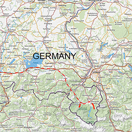
berchtesgaden
Although I live less than 300 km away from the Alps, I hadn't been there before because I am usually thinking that I can go to places near my home any time — and therefore am not doing it, considering it not as priority. In September 2010, I finally decided to spend a weekend in the Alps photographing landscapes and wildlife. My travel destination was the Berchtesgaden Land which is a small piece of German territory in the mountains near Salzburg. Most of it is protected by Berchtesgaden Biosphere Reserve. The core of the reserve is the Bechtesgaden National Park — the only German national park in the Alps. With the service of only 210 km², it isn't very large but has all major alpine habitats and is home for some interesting animal species that I was hoping to find.
I booked accommodation in a private boardinghouse in the village Ramsau the day before departure. Compared to the amounts that I pay for staying in a tent in my Africa trips, it was a real bargain and by far more comfortable. I spent only 106€ for three nights in a double room with breakfast. Although I was alone, I couldn't get a single room because there was none. If a second person were with me, we had to pay only 20€ more.
I went there by car. Having left my home in Erlangen on Friday evening, I reached Ramsau in about 3.5 hours. For the return on Monday morning, I needed even less time — only 3 hours. On the location, I spent 2 whole days.
The weather was not very good. On the first day, it was cold and rainy — as most of the time in that summer, though it wasn't unusual for September. On the second day, there was now and then sun in the valleys but cloudy and quite much mist at the elevations above 1200 m above sea level.
The subjects that I was planning to photograph were alpine marmot, chamois, ibex, and of course, landscapes. Since I went by car, I took also complete equipment for macro photography — just for the case when I come across a suitable subject. It proved to be unnecessary, however, because of the weather.
On the first day, the morning was spoilt by rain. In the afternoon the weather got better, and I went looking for marmots. The excursion was quite successful despite great numbers of tourist hikers who were disturbing me and the animals. The next day, I preferred to go to more remote places in the mountains hoping to find chamois and ibex — but at least some landscapes without people. In search for wilderness, I climbed an almost 2.4 km tall mountain.
photographing marmots
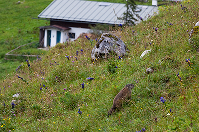
Alpine marmots can be found on pasture, near houses and restaurants.
Marmots were the most important subject for me in this trip. The photo session with steppe marmots in Ukraine in March fueled my interest in other marmot species. But only one else lives in Europe, and of course, I was planning to find and to photograph it since then. Therefore the main goal of this trip to the Alps was to photograph alpine marmots rather than other wildlife.
Unfortunately, I couldn't find any printed in-depth information on alpine marmot populations in Germany. So my knowledge of where to look for them in Berchtesgaden Alps was based solely on the information that I found at the official website of the national park (www.nationalpark-berchtesgaden.bayern.de). In the programme of official guided excursions that the park office offers to tourists (by the way, free of charge!), there is one which goes to marmots. It was mentioned in the description that the marmots like to stay on southern slopes, and that Königsbachalm is the best location for sighting of them. In German and Austrian Alps, the word "Alm" means "montain pasture". From my experience with bobaks (steppe marmots) I knew that they like places with low grass and prefer to build their colonies on pastures. I also had seen some photos of alpine marmots in natural environment that gave me an impression of what the place where they live looks like — like a meadow with singular stones.
A couple of months earlier I purchased a new navigation system (Garmin Oregon 450) and topographical map software which helped me so much that I can definitely say that I owe the success of this trip to it. I also brought a laptop with me. It was easier and quicker to plan the routes with the software on a computer screen than on the small display of the navigation system. This way I found Königsbachalm and planned the route to it from the nearest parking lot. From the excursion programme of national park, I also knew how long a regular excursion takes — 3 to 4 hours. Since I was going to photograph, I was expecting it to be a little longer trip in my case — at least 5 to 6 hours.
Unfortunately, I had to loose much time in the morning because of weather. I even started the excursion at about 11.00 a.m., when it was still raining, and went maybe 1.5 km. Then I thought that the rain would not stop and returned to the car. I left most of the photo equipment in it and went again to the place where marmots should be. I took with me only the main camera (EOS 5D Mark II), the 2.8/300mm lens, a 2x Extender, a flash on a bracket.
It stopped raining at about noon. Soon after that, I reached the slopes at Köngisbachalm, and heard whistles. I spotted the first marmot very quickly — just looked through a binocular in the direction where the sound was coming from. It was quite big and fat, and surprisingly shy. After I approached the marmot closer than 10 m, it escaped into its burrow. I tried the same tactics as with bobaks — waiting quietly at the burrow. However, it didn't work this time. Maybe the alpine marmots are more careful, or their behaviour changes with the season: In spring, hungry marmots want to go out and feed as soon as possible, but in the autumn, when they are fed, they can stay in the burrow longer. The burrows of alpine marmots look different than of bobaks: While there are earth hills behind the entrances of bobak burrows, alpine marmots appear to dig their burrows at stones, and there are no recognizable hills at all. The first marmot that I saw and that escaped to the burrow was more patient than me and stayed inside until I went away after long waiting. When I approached the entrance, the animal was whistling, i.e. it was seing me somehow when it was inside. Apparently, bobaks couldn't this.
The whistling of alpine marmots differs from that of bobaks, too. Its sound appeared to me louder and deeper. Unlike bobaks who whistle once a time, the alpine marmots do it twice. The whistling of alpine marmots is very well distinguishable, i.e., in my opinion, it can't be mistaken for a bird voice by someone who is familiar with the local birds. The marmots see a man before he sees them, but they quickly reveal themselves through the noise that they make. If you are going to photograph marmots, you only need to listen carefully for whistling, to be able to find them. Since they are grey and stay near grey stones, a binocular is very helpful for spotting of them from a distance.
To get a decent photo of the alpine marmot (in that season and at that location), a short supertele lens, such as 300 or 400 mm, or a zoom lens like 100-400 mm, should be enough, but sometimes, with shy individuals, you will have to use a teleconverter. However, at rainy weather the light was too deem for use of teleconverter. After I noticed that the images were not very sharp, I was trying to get closer to the animals to be able to use a bare lens. Adults were generally very shy and weren't allowing me to approach them closer than a 8 m. Young animals were much more brave. Therefore I could get some close-up photos of them with a 300 mm lens from a distance of only a few meters.
The lighting was not good. Most of the time I had to use flash. The natural light was so deem, that a flash was necessary as main light source. But I was trying to avoid it because otherwise it could be noticeable in the images. I was using the flash to light up the subject only a little, and therefore had to set still a long exposure in the camera. All images that I took that day using flash were with aperture 5.6-8.0, exposure time 1/50s and ISO 200-400. Due to a fairly long exposure many were blurred but about 80% were good.
landscape photography in berchtesgaden national park
Since the weather on Sunday, according to forecast, was going to improve, I was planning the day in the evening of Saturday. I didn't want to go again to places with many people because I was going to photograph landscapes and shy animals — such as chamois and ibex. Overall, the presence of large numbers of people where it should be a "wilderness" was not unexpected for me but still quite disappointing. So I decided to look for "real" wilderness.
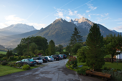
A view from the window of the room where I was sleeping. On Sunday morning the sky was clear and the mountain Hochkalter was visible. After breakfast, I went to one of its summits — Rotpalfen.
The way I chose the destination for my next photo excursion was maybe naive and venturesome at the same time, and, as I learned later, could even have fatal consequences. But now, after it has ended with success, I am happy and proud to have made that decision.
What I did, was to look on the map for areas in the park with no public roads. There were a few of them — in the mountains. There are two main mountain massifs in the National Park Berchtesgaden: Watzmann and Hochkalter. The second one was near the place where I was spending the nights, and I could see it every morning from the dining room window when I was eating breakfast. The view was very beautiful, and the mountain was looking not very high compared with Mount Gahinga that I had climbed in Uganda just two months before. Indeed, even the altitude of the tallest peak — 2,607 m — was not impressing me in comparison with that of Gahinga — almost 3,500 m. So, I thought climbing this mountain would be just peanuts and I could do it in 6 or 7 hours. Okay, to be sure to have enough time, I chose not the highest peak — Rotpalfen (or Wasserwandkopf) with the altitude of 2,367 m above sea level. My navigation was showing even that the destination point would be at even lower altitude of only 2065 m. The estimated walking distance didn't appear very large, too — only 4.4 km! I thought that even in the worst case, being very tired and walking very slowly, I would be able to make one kilometer in an hour when ascending. But the descending would than take less time anyway... Okay, maybe the whole trip would in reality take a little longer because I would be shooting photos... I thought I would need at maximum 8 to 9 hours..., anyway, if I would leave the hotel after breakfast — at 8.00 a.m. to be on the route at 8.30 a.m., I would be back by 5.30 or 6.00 p.m. — in the worst case! Actually, I was expecting to return much earlier.
On Sunday morning, the weather was very good. At the sky there were almost no clouds and the top of the mountain that I was going to stood lit by the sun, as if it was inviting me. After breakfast, I got in to the car and drove to the point where my walk was going to start. I took my Golite Jam 2 backpack (see review) with me, and had put the following gear into it: 1 camera body (5D Mark II), EF 300mm f/2.8 IS L, EF 17-40mm f/4.0, 2.0x Extender II, flash gun, Cokin filters and a Z-Pro filter holder, Novoflex Quadropod base, Novoflex Classic Ball 5 and some other small stuff. I also took with me a binocular, a small bottle of water, a 0.5l isolation bottle with tea, and a sandwich. Of course, I took those four walking sticks that are the legs of Novoflex Quadropod. Two of them I was using as support for myself during the walk. My bag was weighing at least 13 kg, and I was thinking again how great it would be to hire a porter — like in Africa.
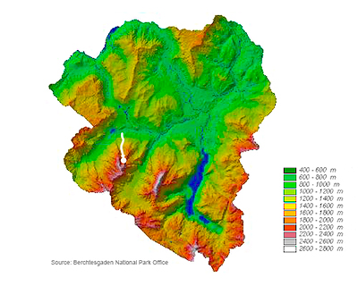
The elevations map of the Berchtesgaden natural reserve with my route marked white.
My route began at the parking lot near Seeklause — a place just at the park border near the lake Hintersee. First I went about 1 km on a tourist road. Then the navigation guided me into a dense coniferous forest. In the forest, it was a path which was used by park personnel for inspections (so called "Forstbegangsteig"). After about 1.5 km this path was getting narrower and finally disappeared. The navigation was guiding me on a very narrow path which in fact wasn't a human path any more but apparently was used by chamois. The last third of the route was going over a pine grove and finally over rock debris.
The walk was really tough. When I reached the first dangerous passage after the first half an hour of walk, I got serious doubts that I was strong enough to reach the top with my heavy baggage. My first thought was even to give up and to return but I overcame the panic and continued. Further, there were several dangerous moments again but I had went already too far and considered that to cease the excursion wouldn't make much sense because those places that I had already passed would be on my way back. I decided that one such place more or one less didn't matter any more and continued climbing.
The ascending took about 6 hours. I arrived at the top of the mountain at about 2.30 p.m. The weather at high altitude had already got bad. The whole area was almost completely covered by mist, and because of that it was quickly getting dark. I set up the Quadropod and took some landscape photos. It was very misty, and I had to wait till the wind blows the cloud away for a brief moment. The view was fantastic! Of course, the colours were dull due to diffuse light and the scenery was lacking contrast, but the place was looking even more surreal because of that.
I spent only an hour there and began descending because I had to reach my car before darkness. First I didn't disassemble the Quadropod. On my way down the slope, I made a couple of stops, put the Quadropod on the earth an made a shot or two. After I reached the forest, I screw off the walking sticks and put the the base and the head along with all other equipment (binocular, camera, etc.) into the backpack. I needed to free both hands (to hold walking sticks), and the equipment to be in safety in case I would fall. Actually, I did fall several times on my way back — because I was very tired and because it was sometimes more difficult to descend than to ascend. Sometimes I lost the path, but the GPS navigation helped me to find it again. I din't make any breaks for rest because I was in a hurry to reach the bottom of the mountain till sunset, and it was getting dark very quickly.
The descending took almost 5 hours. I was lucky to pass the most dangerous parts of the way when I still could see them. When I reached the bottom of the mountain, it was night. I had to continue my way to the parking lot in the forest in almost complete darkness — without torch. Fortunately, that last part of the way was for tourists and safe for walking. Though my car remained alone on the parking lot, I couldn't see it first and had to search for it — so dark it was!
This excursion was possible only thanks to the GPS navigation system. Maybe it even saved my life. Of course, it is generally possible to climb this mountain with a good map, but if I did it, I would have lost much time for orientation, and the time was most valuable thing for me during that excursion which took. Even with GPS, I needed almost 12 hours for it! If I had lost another hour — having looked at the map now and then and lost a couple of minutes every time — the descending would almost certainly have ended for me fatally.
To photographers who would like to climb the Hochkalter massif, I would give the following advices:
- Don't go without a good GPS. Garmin Oregon 450 with a topographic map software of Germany did a great job for me.
- Start the walk earlier — at 6.00 a.m. or so — and be prepared that the excursion would take at least 12 hours — especially if you will be taking photos.
- Take enough water and food. In September, when it is not hot, you would need at least 2 liters water. I had only 1 liter of liquid (0.5 l of water and 0.5 l of tea) and on the way back was thinking that I would die of dehydration. Also the only one sandwich with cheese that I had was too little.
- Don't loose much time when you are ascending, just try to reach the top of the mountain as quickly as possible because you will find the most spectacular landscapes there. If you start at 6.00 a.m., you would almost certainly reach the top till noon. For descending, you would need about 5 hours. So you would be able to spend at least 2 hours at the top. You wouldn't regret it!
- Try the route from Blaueishütte for ascending. The Blaueishütte is a rest house (a hut) for mountaineers which is not far from the top of Rotpalfen. It is very well accessible even for normal tourists on a public recreation way. Someone who isn't afraid of height and is physically strong can go from there to all summits of Hochkalter. If you are a mountaineer or regularly do sports, you can overnight in Blaueishütte and explore the mountain from there. After that you can descend on the same route that I took.
- Unless you sleep in Blaueishütte, take with you only the equipment that you need for landscapes: a camera body, a wide angle lens, a tripod, and maybe gradient filters and a polarizing filter.
final remark
Please, note that everything written above in this report may be not relevant for a different season.